
Features GPS Compass Navigation Pro
From now on your hiking, hill climbing and walking will be easy.
Use compass, navigation, record your routes, save your locations, take photos with GPS tag...
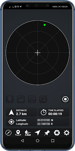
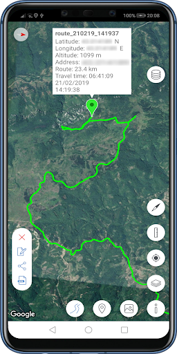
and much more.COMPASS- Magnetic and true north- Azimuth and magnetic field strength- Current location info - Real time calibration monitorGPS NAVIGATION- Recorded route- Route point- Saved place- Location where a photo was taken- Location picked from map- User input coordinates- No internet requiredTRACK YOUR ROUTESSAVE YOUR PLACESTAKE PHOTOS WITH GPS TAGMAP- Load your saved places, photos and routes and show them on map- Visualize route data graphs- Show current location info- Use compass mode- Use measure tool to get distance between two points on map- Switch between map typesMANAGE DATA- Backup your data- Restore your data- Import places, photos and routes from another device- Share your data with your friends- Export your places, photos and routes and visualize them in Google Earth
Social Features
Connect and share with friends and the community.
Camera Features
Advanced camera features with editing capabilities.
Fitness Tracking
Track your workouts and monitor your health metrics.
See the GPS Compass Navigation Pro in Action
Get the App Today
Available for Android 8.0 and above